This was the big one.
Plenty of philosophical stuff popped out, but this post is more of a blow-by-blow.
UTMB is a 105 mile foot race in the French/Italian/Swiss
Alps, with about 31,000’ of climbing. It
follows the popular Tour du Mt Blanc, a hut-to-hut route circling the Mt Blanc
massif. The scenery is spectacular, yet
the route is never too far from civilization. But a big part of the experience is the culture surrounding the race, very different from what I'm used to.
The Start:
The race starts at 5:30pm in the center of Chamonix,
France. I was a bit stressed about the
late starting time; I would certainly be racing through one night, the next day, and at least into the next night. So on race day I slept in a bit (8:30am) and
spent the day doing hardly anything but readying my gear and eating. I tried to stay off my feet, even laying in
shady grass for a while. I'd been bouncing around town for a couple of days, and I was seeking quiet nooks for relief from the crescendo of hype and frantic energy that surround the races.With 2400 runners, the starting area gets packed around the block. Some runners show up early and sit on the ground to reserve a place near the start line. The rest of us filed in between 4-5pm with ever increasing density. This year, the threat of rain added to the excitement. A passing shower or two coaxed a bunch of parkas out of the packs. When it stopped raining, off came the parkas. (This is not easy when you are basically a sardine.) After a “briefing” at 5pm and some heroic-sounding words and music, a very dark cloud appeared. Just when the starting horn went off, it started pouring. By then, I’d decided I was going to run wet for a while and left the raingear in the pack. Oregonian that I am, this was fine. I could pull out the gear if/when it got cold up in the passes or into the night.
 |
| Waiting for the start |
Twilight (0-31km)
The first few km are the easiest part of the entire course,
mostly flat and rolling. By the edge of
Chamonix, we were running more or less freely.
A lot of runners could be seen sneaking relief to the side after holding
it in for 1-2 hours at the start. Fortunately
there is no single track for the first 15k, so the field has a chance to spread
out. I found myself passing people in a
relaxed sort of way, gradually finding my way toward my pace group. More spectators appeared at places all along
this stretch. After about 45 minutes
like this, we rolled into Les Houches (where I recognized a Romanian fellow
from the CCC race I’d met at the hostel).
I ran straight through this aid stop, having not consumed much water or
food yet.
Following Les Houches, the race launches into the first real climb, and out came all the poles. The runner density was still high, but the route was still following a road (mostly dirt), so there was room for everyone and their poles. By now, most of the overenthusiastic starters had settled into a more reasonable pace for a ~30+ hour race. It was still raining steadily, but with the exertion I was ok being wet, even though the majority still had their raingear on. At this point, my mission was to be efficient and not overdo it.
Following Les Houches, the race launches into the first real climb, and out came all the poles. The runner density was still high, but the route was still following a road (mostly dirt), so there was room for everyone and their poles. By now, most of the overenthusiastic starters had settled into a more reasonable pace for a ~30+ hour race. It was still raining steadily, but with the exertion I was ok being wet, even though the majority still had their raingear on. At this point, my mission was to be efficient and not overdo it.
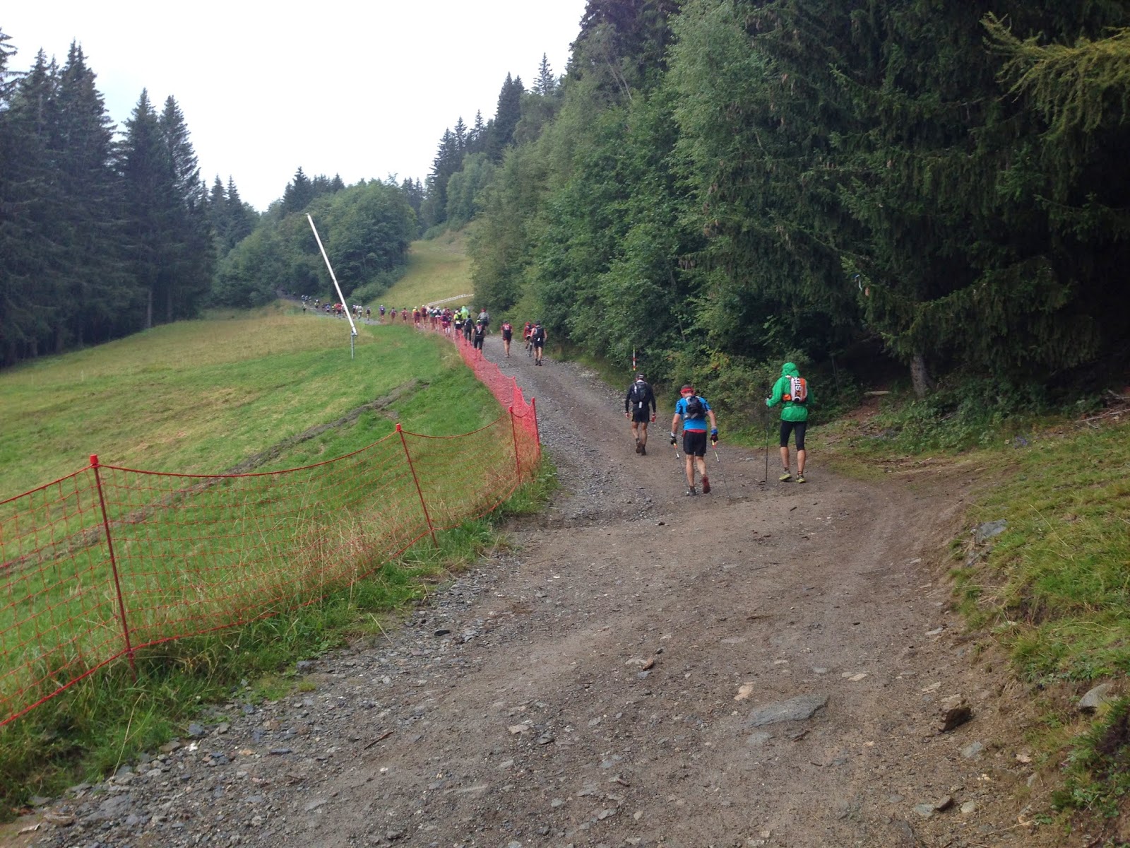 |
| First big climb |
 |
| Looking back |
 The stretch from St Gervais to Les Contamines looks fairly tame
on the profile, but it has a fair number of short steepish climbs. My strategy was to “work” the route, running
when it made sense, taking the hard parts steadily but not too hard. It did seem to take a long time, and I was
seeing a little carnage along the way.
The transition to night seemed to darken the mood too. I managed to emerge at Les Contamines at 3 ¾ hrs
in good shape, headlamp shining. The
town was lively, although nothing like St Gervais. I only spent a couple of minutes in the aid
station, my mindset all business.
The stretch from St Gervais to Les Contamines looks fairly tame
on the profile, but it has a fair number of short steepish climbs. My strategy was to “work” the route, running
when it made sense, taking the hard parts steadily but not too hard. It did seem to take a long time, and I was
seeing a little carnage along the way.
The transition to night seemed to darken the mood too. I managed to emerge at Les Contamines at 3 ¾ hrs
in good shape, headlamp shining. The
town was lively, although nothing like St Gervais. I only spent a couple of minutes in the aid
station, my mindset all business.
Down to Business (31-50k)
I was now on Terra Cognita, having recce’d this part of the
course a few days earlier. The route
works its way up a broad valley, ultimately climbing about 1500m to the Col du
Bonhomme (39k). I was glad to have seen
this during the day, because it’s a beautiful place. From Les Contamines the climbing is very
gradual, but it gets serious after Notre Dame de la Gorge, where the last
casual spectators would be for a long while.
Because I knew what to expect, I was able to pace myself well.  |
| Climb to La Balme, a few days before the race. |
I left La Balme in high spirits. Maybe the rain tapering off had something to do with it. The route ahead was outlined by a string of headlamps working their way well above, and looking back I could see even more lights strung out all the way into the forest near the valley bottom. It’s hard to convey this effect, maybe like being part of some infinite slithering snake. It’s one of the highlights for sure.
 I was starting to feel a bit of cramping in my feet, the
kind of thing that often disappears but you don’t want to ignore it. The feet seemed happier if I took quicker,
shorter steps on the climbs. After an
hour of steady climbing, I reached the Col Bonhomme at 6 hrs, and 20 more minutes
got me to the summit checkpoint at Croix du Bonhomme. There are two kinds of UTMB checkpoints: the
aid stations (generally down in the valleys) had timing mats, while each summit
(cols and so on) had a person with a wand to read our bibs.
I was starting to feel a bit of cramping in my feet, the
kind of thing that often disappears but you don’t want to ignore it. The feet seemed happier if I took quicker,
shorter steps on the climbs. After an
hour of steady climbing, I reached the Col Bonhomme at 6 hrs, and 20 more minutes
got me to the summit checkpoint at Croix du Bonhomme. There are two kinds of UTMB checkpoints: the
aid stations (generally down in the valleys) had timing mats, while each summit
(cols and so on) had a person with a wand to read our bibs.
I knew the next 1000m descent would be steep and tricky, and
was again glad to be familiar with the terrain.
In training I’ve been working on making my way down technical stuff
efficiently, like “dancing” down the mountain.
Besides minimizing wear and tear, I have a lot more fun with the run
this way. I have not historically been
the fastest downhiller, but found myself overtaking people on this
stretch. Lately I've been using a new headlamp trick of wearing one at the waist. This works great in fog/mist (think fog lights), and also brings out relief of features in the trail. Since we're required to have a spare light, I figured I might as well wear one on the head too. For slow sections (uphills) I would just use the upper lamp, and used both for the wild descents such as this one.
I cruised into the charming Chapieux and its aid station 7 hours into the race (a little after midnight), welcomed with enthusiastic cheers from a few onlookers. Here all runners were subjected to a bag check. Reasonably, the man asked to see pieces rain gear. But then he looked up at me with concern and said “la puce?”. My French is not great, and I certainly didn’t know what a puce is. I proffered various items I thought might appease – my phone, gloves, passport, bandage, etc. This didn’t assuage him, and he called over the supervisor. I finally realized “la puce” is a card/chip that was attached to my pack with a tiny cable tie at registration. To my horror, it was missing! After much gesturing and attempted explanations, the supervisor took pity and let me through. I wasn’t sure if I would be eventually penalized or not, and for a while the thought would periodically bubble up that I might be DQ’ed, or whatever, and it wasn’t fair because I didn’t do anything wrong, etc. (Spoiler – nothing came of it.)
I cruised into the charming Chapieux and its aid station 7 hours into the race (a little after midnight), welcomed with enthusiastic cheers from a few onlookers. Here all runners were subjected to a bag check. Reasonably, the man asked to see pieces rain gear. But then he looked up at me with concern and said “la puce?”. My French is not great, and I certainly didn’t know what a puce is. I proffered various items I thought might appease – my phone, gloves, passport, bandage, etc. This didn’t assuage him, and he called over the supervisor. I finally realized “la puce” is a card/chip that was attached to my pack with a tiny cable tie at registration. To my horror, it was missing! After much gesturing and attempted explanations, the supervisor took pity and let me through. I wasn’t sure if I would be eventually penalized or not, and for a while the thought would periodically bubble up that I might be DQ’ed, or whatever, and it wasn’t fair because I didn’t do anything wrong, etc. (Spoiler – nothing came of it.)
Anyway, back at the aid station, I stocked up on food,
water, and a sip of Pepsi, and off I went.
Through the night (50-77k)
 |
| Vallee des Glaciers, a few days before the race. |
 |
| Descent to Courmayeur (taken a few days earlier). For the race, this was late at night. |
 |
| Courmayeur (I think) |
Back in the daylight (77-100k)
I did not plan splits much, but I figured a 30 hour finish
(my “A” goal) would be consistent with about 12.5 hours at Courmayeur (it’s not
quite halfway). So leaving Courmayeur at 12.5 hours had me thinking that the 30 hour
goal was certainly in reach. Michael and
I hiked and chatted our way up from Courmayeur, not pushing too much so as to
digest. It was maybe half an hour before
he pushed ahead. I hit the next aid
station at Refuge Bertone right after sunrise, and was rewarded with fantastic
views across the Vallee d’Aosta to the Mt Blanc Massif.
This was a great stretch of the course – the terrain was rolling for the next 10k or so, a rare opportunity to make good time. While my pace was good, I kept stopping for photos, and then for a herd of cattle with scary sharp horns using the trail! One cow was so close I felt her hot breath on my arm.
I was starting to notice some soreness in my back. I worked on using better posture, and tried using
better downhill technique to limit impact.
I did not want core structural problems to develop. The shortish descent to Arnuva was steep, and
it was hard not to feel pounded. The
Arnuva aid station, like the others, made me feel like a rock star again, but I
didn’t want to dally while I was moving well.
After the Arnuva stop, there is a solid 750m climb up to the Swiss border at Grand Col du Ferret. At some point, I passed by a racer named Michael who had sat down, enjoying the view, saying quite clearly “good job, man”. Well, it wasn’t until I was well past him that it registered he was American. I realized later that it was probably the intrepid Michael Wardian, who is obviously not afraid to try things far afield from his usual routine (like acing marathons). It sure would have been nice to chat him up a bit. The top of the Col was enshrouded in fog, which for me was welcome because the day was starting to heat up.
 |
| Sunrise near Bertone |
 |
| A little past Bertone |
This was a great stretch of the course – the terrain was rolling for the next 10k or so, a rare opportunity to make good time. While my pace was good, I kept stopping for photos, and then for a herd of cattle with scary sharp horns using the trail! One cow was so close I felt her hot breath on my arm.
 |
| Hot-breath sharp-horned cows. |
After the Arnuva stop, there is a solid 750m climb up to the Swiss border at Grand Col du Ferret. At some point, I passed by a racer named Michael who had sat down, enjoying the view, saying quite clearly “good job, man”. Well, it wasn’t until I was well past him that it registered he was American. I realized later that it was probably the intrepid Michael Wardian, who is obviously not afraid to try things far afield from his usual routine (like acing marathons). It sure would have been nice to chat him up a bit. The top of the Col was enshrouded in fog, which for me was welcome because the day was starting to heat up.
 |
| Climbing Grand Col du Ferret |
 |
| Just before the summit. Last view from Italy. |
Onward through the fog (100k-124k)
Now in Switzerland, I knew there was a long descent to the
next aid. Research showed this to be a
long stretch between aid, but today I forgot to fill the extra bottle at
Arnuva. Fortunately 1L was just enough. The descent to La Fouly seemed awfully long,
but in retrospect it might have been one of my strongest sections. Somehow I jumped from 133rd to
115th in just over an hour. I was going
through head games, just really wanting La Fouly to be there. “It must be down in that little valley” (nope),
or “I can hear the spectators’ cowbells” (it was cows, actually). Sometimes I get in these time warps where
progress seems way too slow, even though my pace is ok. When I finally got to La Fouly, I spent only a
few minutes to restock, wanting to keep the momentum.
 |
| Entering Switzerland |
The next stretch to Champex-Lac was one of my lower
moments. By now the sun was out in
force, and I was feeling the effects. I
think I would have handled this stretch a lot better if I either knew what was
coming or I just took it as it came.
Instead I was a little peeved that it wasn’t easier. That said, this section goes through a huge
valley lined with gorgeous towering mountains studded with imposing limestone
cliffs, and it was hard not to be impressed.
I stopped to put sunscreen on. I
was aware that my calorie intake was behind, and now saw that my pee color was
a little dark. As I write this, I
realize this new worry gave me something to focus on. I worked on hydrating better, and tried to
down some gels and Trail Butter. The
stomach was a bit queasy, though, and I’d already used up my 2 Rolaids (I might
bring more next time). The trail went
down the valley for quite a ways, across rolling terrain that was often rocky
and hard to get into a rhythm. I started
psyching myself out with thoughts of “do you realize how much is still ahead?”. Basically, what was ahead was the challenging
OCC race run the day before, which is 54k and 3000m+ climbing, which didn’t
seem that straightforward after almost 20 hours of hard running.
 After what seemed a long time, the trail dropped
into the valley bottom at a small hamlet, which I very much hoped was the next
aid station (nope). Then it crossed back
and began an honest climb for about 300m to Champex-Lac, where the aid station
really was. Along this “when will this ever
end” section, I was suddenly delighted to meet the Irish ladies I’d befriended
during the recce a few days earlier. It
was such a lift to have my own personal cheering squad in the middle of
nowhere, when I needed it most. The
icing on the cake was a spring water source that I delved into with gusto, as I
had just emptied my supply. A
confession- I’m not a very “social” person, and am used to going solo. But encounters like these remind me that,
even as a serious introvert, family and friends (however new) make a huge
difference in my life. After a brief
chat with the ladies and with buoyed spirits I finished the climb to the aid
station.
After what seemed a long time, the trail dropped
into the valley bottom at a small hamlet, which I very much hoped was the next
aid station (nope). Then it crossed back
and began an honest climb for about 300m to Champex-Lac, where the aid station
really was. Along this “when will this ever
end” section, I was suddenly delighted to meet the Irish ladies I’d befriended
during the recce a few days earlier. It
was such a lift to have my own personal cheering squad in the middle of
nowhere, when I needed it most. The
icing on the cake was a spring water source that I delved into with gusto, as I
had just emptied my supply. A
confession- I’m not a very “social” person, and am used to going solo. But encounters like these remind me that,
even as a serious introvert, family and friends (however new) make a huge
difference in my life. After a brief
chat with the ladies and with buoyed spirits I finished the climb to the aid
station.
In the groove (124-156km)
Champex-Lac is one of the “major” stops, with plenty of
soup, snacks, and where runners can meet their crew (for those fortunate
enough). I took 25 minutes take care of
things and put myself back together, time well spent. At 20 ½ hrs, I left the aid station and after
a bit of bewilderment looking for the right way found the path through
town. Champex-Lac is a beautiful resort
town nestled in a large hanging valley with a crystal blue lake as the
centerpiece. Many visitors must be
tempted to jump in those crystalline waters.
My goals were different than its guests, however, and I wasn’t in my
element until I was back on the trail for a few km. It sounds weird, but it was powerhiking the
next big climb that finally got me back into the rhythm. By this point in the race, I was pretty much
holding my place. Generally, I would get
passed by a few on the climbs, then pass back on the downs. This surprised me, because I’m not the
fastest descender, but I suppose some runners were probably having their quads
blow up by now.
 |
| Focused, somewhere |
I have to say, it was really fun coming through each village
– people were out in force, cheering on all runners regardless of nationality
(or mood!). I never got used to complete
strangers yelling “Go, Rick!” (yes, they often switched to English when they
saw the American flag). But I was to get
an added boost in Trient – more folks from my recce a few days ago! This time, it was some of the folks from the
“Chicago 12”. They cheered me into the
aid station, where I had singular purpose.
Somewhere this afternoon, I got to feeling that I should get in and out
of aid stations more quickly (but still doing what needed to be done). While I was chugging soup and a few snacks,
the announcer on the PA was excitedly saying I was runner #100. What? I
hadn’t expected to do that well, and really had no clue what place I was
in. While I wasn’t trying to be top 100,
this revelation was a tremendous ego boost.
I responded with some kind of victory wave or something. I realized I must be having a great day, this
was going to happen. (Meanwhile, anybody following me would know
exactly my times and place at each checkpoint.) Just two more mountains – I wanted to get it
done.
The Chicago folks were still there to offer support heading
out, even asking if I needed anything! A
very welcome emotional boost. The next
climb was much like the last. Again a
few folks passed me on the way up, though I was happy with my pace. A bit of rare rolling terrain at the top
brought me to the Catogne checkpoint at the summit. Not much to say about the descent, except
that it felt longer than I thought it should be, mind games again. I don’t remember passing many going down, but
somehow I arrived in Vallorcine in pretty much the same place as Trient. I figure that a few runners were probably
lingering longer than me in the aid stations.
I apparently stayed about 8 minutes in the aid station, although it
seemed like 2. Guess I wanted to make
sure I had enough for the final push. Around
26 hours into the race, I was heading out of Vallorcine.
I did leave Vallorcine aggressively. There was a runnable section up to Col des
Montets before the major climb, and I took advantage of it. After Montets, there is a ruthless climb up
to Tete aux Vents, the final summit.
This had me in a pretty good mood, and it didn’t matter that a couple of
guys passed me. Darkness fell, and out
came the headlamps (further into the race then I ever hoped for). After a lot of solid climbing, the steepness
eased but the climb still continued over rugged rocky terrain until at last
topping out at the checkpoint.
Final tribulation (156-168k)
This section gets disproportionate attention because it will
stick with me more than any other. I
expected the first part of the final descent to be runnable moderate downhill
for 3k to La Flegere. It turned out to
be very technical and bouldery, with lots of hopping, scrambling, and toe
stubbing. It did not help that much of
the ground between boulders was muddy, making the footing on rocks
slippery. Naturally I was getting pretty
pissed about how unfair this was (never mind that everyone else had exactly the
same challenge). My mental groove was derailed. This is how it goes with these hundred milers
– one section you’re on cloud nine, the next you’re in cellar. Fortunately, it was around here that I
started chatting with the energetic Aussie runner Tegyn, who commiserated
appropriately without magnifying my negativity.
After maybe the 10th major toe-stub, I was actually yelling
at myself to get my shit together and not do that anymore dammit (I’ll leave
some of the language to the imagination).
We could see the bright lights at the La Flegere checkpoint, but as we
got closer it was clear that we would have to climb up to it! This was too much – a 50m climb, when we’re
supposed to be on our last descent? It’s
not fair! Or, at least it’s not effective
trail layout. Got to blame someone,
right? I’d also been getting this idea that
I could beat my 30 hour goal, but the technical section had me wondering if I’d
make it.
Well, we somehow managed the final 50m climb and made the
checkpoint. I was completely surprised
by a fairly well-stocked aid station in the tent, which as far as I know was
not promised. I dumbly stared around not
knowing where to go, then finally got shown out the back door. No time to waste with 8km 1000m descent of unknown
difficulty, with 77 minutes left (yeah, I was pretty focused on 30 hours by
now). With Tegyn leading the way, I went
to work. The first few km were steep but
not too technical, mostly on the very rough gravel roads of a ski area. While the pace was not great, at least we
were moving again. I gave up on any
estimate of distance after the discouragement of the last section, so I started
fixating on the twinkly lights of Chamonix far below. This idea was no better, as the lights still
seemed just as far away after a lot of pounding. The grade eased, and there was nothing to do
but keep running. Tegyn and I passed a
couple of runners on this descent who must have been in even more pain than
us. Then suddenly the lights weren’t so
far away, and we started seeing signs of civilization. The road got smoother, a few parking areas, a
building or two, then pavement! I still
didn’t know how much was left, but by now the momentum was established and it
was like we were on a conveyer belt. As
we rounded the turn parallel to the river, it was obvious we’d run this in
together.
Tegyn remarked that we were pulling 5:15 per km (low 8
minute miles)! This is not normally considered a sprint pace, but it was for us. It was a ridiculous way to finish, really, but not a conscious decision. Even at 11pm, there were
hundreds maybe thousands of people cheering runners in, far more than I’ve ever seen
in all my trail races day or night. This really is a
glorious scene with lots of fanfare. We
were chasing no one, being chased by no one, but we kept hammering through the
final turns in central Chamonix and crossed the finish line in style in
29:41. Tied for 98th place, 4th
in age group.
 |
| Blazing across the finish |
It took me awhile to stabilize after that silly finish. I eventually headed over to join other
zombies for the free dinner and showers offered by the race, then finally
stumbled my way to the hostel where I’d reserved a bunk in case of a strong
finish and slept quite soundly.
I couldn’t have asked for a smoother race. I was lucky to have great training terrain
where I live (Columbia Gorge, Mt Hood).
I am also blessed with great training partners. My training volume was higher than I’ve ever done, and not so much that
I was burnt out. In a sense, UTMB was a
1400 mile race that started in March, because since then pretty much all of my
running and hiking (and dreaming) has been about UTMB. 5000 miles if you add in qualifying races. I'm still sorting out the psychic aspects;
I’ll save those for another post.
Gear:
Montrail Mountain Masochist (good choice for the
conditions)
Injinji socks
Salomon Slab-12 pack, w/ 3x500mL collapsible bottles.
BD Ultra-Distance poles (first race with poles, really glad I had them)
Headlamps: Petzl Myo Rxp (worn at waist) & BD storm (on head)


